Subscribe
Land Records
Computerisation of Land Record - An Innovative Approach to Management
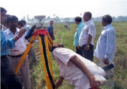
Computerisation of Land Record (CoLR) was initiated by Ministry of Rural Development, Government of India. Latest tools of Information Technology such as Geographical Information System (GIS), Cadastral mapping, Photometry, Electronic Total Station (ETS), Global Positioning System (GPS)...
NLRMP: A Holistic Approach to Land and Property Management
1. In an exclusive Interview to Informatics, Smt. Rita Sinha, IAS Secretary, Department of Land Resources, Ministry of Rural Development, Government of India, expressed her views on how National Land Records Modernization Programme (NLRMP) will be instrumental in implementing the conclusive land-titling...
East Medinipur: Demonstrating outstanding e-Governance Activities
The district of East Medinipur (or Purba Medinipur) has been carved out of erstwhile Medinipur district on January 1, 2002.It is one of the 18 administrative districts of West Bengal with its headquarters located at historically famous, Tamluk. This is one of the three Districts in India which declared...
Hazaribag - Harnessing ICT for Good Governance
Hazaribag- literally meaning City of Thousand Gardens, is situated at 2019 ft above the sea level in the North Chotanagpur Plateau. Congenial salubrious climate, abundant flora, fauna, wildlife sanctuary, lakes and hills have attracted tourists to this place since long and is also considered as a health...
 Flipbook
 PDF (4.5 MB)