Search

Advanced Search

Cadastral Maps (Mussavies) Digitization & Integration of Bhu-Naksha & HALRIS

Poonam Gupta, Haryana poonam[dot]g[at]nic[dot]in
  |   Feb 9, 2011
FCR Sh. Naresh Gulati is reviewing and inspecting the lab in the presence of  Commissioner Ambala, DC Ambala and SIO Haryana.
FCR Sh. Naresh Gulati is reviewing and inspecting the lab in the presence of Commissioner Ambala, DC Ambala and SIO Haryana.

One Cadastral Maps digitization Lab & Integrated Bhu-Naksha & HALRIS software solutions has been set up for 40 on-line villages of Ambala Tehsil at Mini Secretariat Ambala.
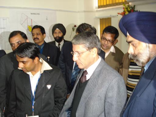
On 20th January, 2011, FCR Sh. Naresh Gulati has reviewed and inspected the lab. The complete demonstration of HARIS-HALRIS-Bhu Naksha linkage was given to all officers. After the demonstration, FCR has asked Commissioner Ambala Division Sh. Anil Kumar, DC Ambala Sh. Sameer Pal Srow & SIO NIC Haryana Sh. G.S.Bansal to start the implementation on pilot basis.
The Bhu Naksha software was developed by NIC CGSU and was got customized by incorporating Haryana specific requirements and it was integrated with HALRIS having following features:
1.Importing digitized Cadastral map, provided by the HARSAC to Bhu-Naksha software.
2.Displaying the digitized map of the village.
3.Displaying the particulars like owner names and area of the selected khasra on the map,   picking directly from the HALRIS database.
4.Tatima of the khasra during the mutation entry, using various options.
5.Khasra Nakal of Sajra Aksh along with owner’s details.
6.Map based queries like displaying of Govt.land on the map.
7.Printing of Textual RoR as well as map of the plot.
The primary objective was to provide authenticated and secured Nakal of Record of Right services as integration of HARIS#HALRIS#BhuNaksha to the citizen of Haryana along with updated map of their land.
This project is one of the very prestigious e-Governance projects and complex in the nature as it provide the interface of Land Revenue Administration, property registration and linkage of textual spatial land records data in integrated manner on authenticated as well as authorization basis.


Recent Issues

Highlights

Apr. ' 24 Issue


UEBA: An In-depth Exploration of User and Entity Behavior Analytics

UEBA revolutionises cybersecurity by scrutinising the behaviour of users and entities within a network...


TS-eMining: Geological & Mineral Resources Planning

TS-eMining application has digitized and streamlined mineral resource management processes in Telangana. It facilitates ...


Online Policy-Based Transfers System: A Comprehensive System for Implementation of Bulk Transfers

The Online Policy-Based Transfers System simplifies employee movement within the government, replacing paperwork ...

Jan. ' 24 Issue


Cyber Risk Insurance: Insurance Policy to cover financial liabilities arising from cyber incidents

Cyber Risk Insurance, also simply known as Cyber Insurance, is a kind of insurance policy which protects business ...


SATHI: An ecosystem where each seed tells its own story

SATHI, or Seed Authentication, Traceability & Holistic Inventory, strives to create a nurturing digital environment. ...


Unified Data Hub: Empowering Proactive Governance through Integrated Solutions

UDH has established an adaptable system for validating and eliminating duplicate beneficiaries. Presently, it encompasses ...

Oct. ‘ 23 Issue


Emerging AI/ML Attacks and Risks Navigating Emerging AI/ML Threats in Application Security

In the era of relentless innovation driven by Artificial Intelligence (AI) and Machine Learning (ML), applications ...


Advanced Persistent Threats Threat Landscape and Countermeasure

In the digital age, Advanced Persistent Threats (APTs) pose a persistent and evolving menace. APTs, orchestrated by ...


TejasVI Empowering Data Driven Governance

TejasVI transforms data analysis / visualisation for eGovernance through its user-centric design, integrating various ...