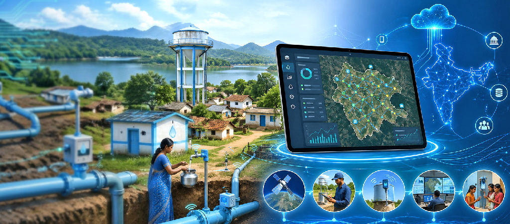
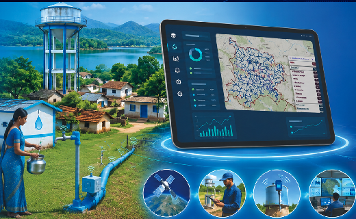
Mission Bhagiratha’s Enterprise WebGIS platform transforms rural water supply into a data-driven governance system. By integrating geospatial asset mapping, habitation-level monitoring, real-time analytics, and national platform linkages, it enables end-to-end visibility, improves service reliability, and establishes a scalable, replicable model for technology-enabled public infrastructure management.
Mission Bhagiratha is a flagship drinking water initiative of the Government of Telangana, designed to deliver safe, treated piped water to every household in the State. Covering nearly 1 crore citizens across 55 lakh households, it represents one of the largest centralized rural water supply networks in the world. At this scale, infrastructure alone is not enough—what becomes equally critical is visibility, traceability, and the ability to govern the system in real time. To address this, the State has implemented an advanced Enterprise WebGIS-based Water Infrastructure Management System. The platform serves as a statewide spatial decision-support system, providing end-to-end visibility across the water supply value chain—from source to service delivery. In doing so, it establishes Telangana as a national benchmark in technology-enabled water governance.
An Integrated Digital Water Network Architecture
The Enterprise WebGIS platform provides end-to- end geospatial visibility of the entire water supply value chain—from raw water abstraction to last-mile household distribution. It integrates and spatially maps all critical infrastructure components within a unified digital environment, enabling a comprehensive view of system design and operations. The system brings together the following infrastructure layers:
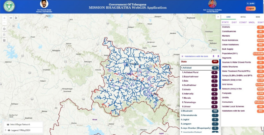 Fig: 9.1 : Mission Bhagiratha WebGIS Application
Source and Bulk Water Infrastructure
- Surface water reservoirs
- Intake wells and intake structures
- Raw water transmission mains
- Water Treatment Plants (WTPs)
Treated Water Storage & Regulation
- Sumps
- Ground Level Balancing Reservoirs (GLBRs)
- Break Pressure Tanks (BPTs)
- Overhead Balancing Reservoirs (OHBRs)
- Overhead Service Reservoirs (OHSRs)
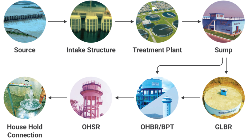 Fig: 9.2 : Mission Bhagiratha Water Supply System
Conveyance & Distribution Network
- Gravity mains
- Pumping mains
- Pumping stations and electromechanical assets
- Control valves and pressure regulation systems
- In-village distribution networks
- Functional Household Tap Connections (FHTCs)
By integrating these components within a single geospatial framework, the platform enables seamless visualization of the network, supports system-level understanding, and provides a reliable foundation for planning, monitoring, and operational management.
Zoning-Based Network Governance Model
By integrating hydraulic conveyance components with administrative and habitation boundaries, the system enables end-to-end traceability of the water supply chain—from source sustainability to the consumer endpoint. The WebGIS application incorporates multi-tier administrative boundaries—Segment, District, Mandal, Constituency, and Habitation—systematically linked to corresponding service reservoirs. This structured geospatial architecture provides a consistent framework for planning, monitoring, and governance of the water supply network. Through this zoning-based configuration, officials can compare system performance across regions, reinforce accountability through clearly defined spatial jurisdictions, identify service deficiencies and distribution imbalances, and take timely, data-driven decisions. By linking administrative hierarchies with habitation- level spatial datasets within a unified geospatial environment, the platform establishes a coherent spatial intelligence layer. This integration has significantly improved operational efficiency while strengthening evidence-based infrastructure planning under Mission Bhagiratha.
I am pleased to share that the Mission Bhagiratha Department is advancing toward digital transformation. The Mission Bhagiratha WebGIS-based Water Infrastructure Monitoring System has emerged as a powerful governance tool, strengthening our ability to plan, monitor, and manage the State’s drinking water supply system.
The WebGIS application offers end-to-end spatial visualization of drinking water infrastructure, from surface water sources to the habitation level, enabling effective asset monitoring and long-term sustainability. A key achievement under this initiative is the digitization of nearly 65,000 kilometers of in-village pipeline network within a short timeframe by our field engineers, in accordance with National Jal Jeevan Mission (NJJM) guidelines.
Advanced features such as functionality-wise asset dashboards, Water Quality Laboratories information, and Water Supply Status dashboards have significantly enhanced transparency, monitoring, and data-driven decision-making.
The platform has become an indispensable instrument of governance, aligning seamlessly with the Department’s vision of providing daily potable drinking water to every rural household in Telangana. Its integration with the Irrigation Department’s reservoir water level data and its linkage of asset information with the PM GatiShakti National Master Plan Portal reflect effective multi-departmental coordination.
I place on record my sincere appreciation for the support and technical expertise extended by NIC, Hyderabad, whose contributions were vital to the successful implementation of this initiative.

Shri G. Krupakar
Engineer-in-Chief (ENC), HoD Mission Bhagiratha, Government of TelanganaAdvanced Functional Capabilities
End-to-End Network Coverage Analytics
The GIS platform enables full network tracing from intake structures to habitation-level endpoints. Engineers can assess service coverage and identify partially served habitations, tail-end supply deficiencies, network discontinuities, and distribution inequities. This spatial analysis supports prioritized infrastructure strengthening and more effective last-mile connectivity planning.
Identification of Infrastructure- Deficient Habitations
The system geospatially identifies habitations lacking critical infrastructure, including:
- Absence of OHSRs
- Isolated or remote settlements
- Hilly or topographically constrained areas
- Network dead-ends
These spatial diagnostics enable targeted, micro- level engineering interventions such as decentralized storage, dedicated pumping arrangements, alternative local sources, and network reconfiguration. The result is a more inclusive and context-responsive approach to rural water service delivery.
Large-Scale Digitization of Rural Distribution Networks
In one of the largest rural pipeline mapping exercises in India, approximately 65,000 km of in-village distribution pipelines were digitized within a six-month period. A specialized GIS editing tool within the platform enables precise mapping of village-level pipelines using high-resolution ESRI satellite imagery as the reference layer. This transition from paper-based drawings to geo-referenced digital assets significantly enhances data reliability, supports asset lifecycle management, and enables long-term infrastructure planning.
Real-Time Water Supply Monitoring Dashboard
The platform incorporates a thematic, color- coded geospatial dashboard presenting habitation-level water supply status across the State, enabling rapid situational assessment and time-sensitive decision-making. Supply Status Classification:
- Green – Fully Supplied
- Orange – Above-Average Supply
- Yellow – Partially Supplied
- Red – No Supply
By integrating operational data with geospatial visualization, the system helps identify service gaps and detect anomalies such as pipeline failures, pump malfunctions, power interruptions, or source depletion. This enhances monitoring efficiency, reduces response time, and improves overall service reliability.
Integrated Water Quality Surveillance
The platform maps the State’s water quality laboratory network, including:
- NABL accreditation status
- Testing parameters (chemical and bacteriological)
- Laboratory infrastructure and instrumentation
- Technical manpower
- Geospatial locations
By integrating laboratory data within the GIS environment, the system strengthens water quality monitoring and enables more coordinated surveillance across regions.
High-Resolution Spatial Visualization
Integration with high-resolution ESRI satellite imagery enables detailed visualization and accurate ground-referenced mapping of infrastructure assets. This supports validation of pipeline alignments, assessment of terrain and land-use conditions, and informed planning for new infrastructure. Overlaying asset data onto imagery improves spatial accuracy and reduces field-level ambiguity in decision-making.
A Statewide Geospatial Water Infrastructure Repository
The platform manages one of the largest rural water GIS repositories in India, serving as an integrated digital backbone for the entire infrastructure lifecycle—planning, execution, monitoring, maintenance, and policy formulation. The system currently maintains a comprehensive geospatial dataset of water infrastructure and administrative coverage across the State:
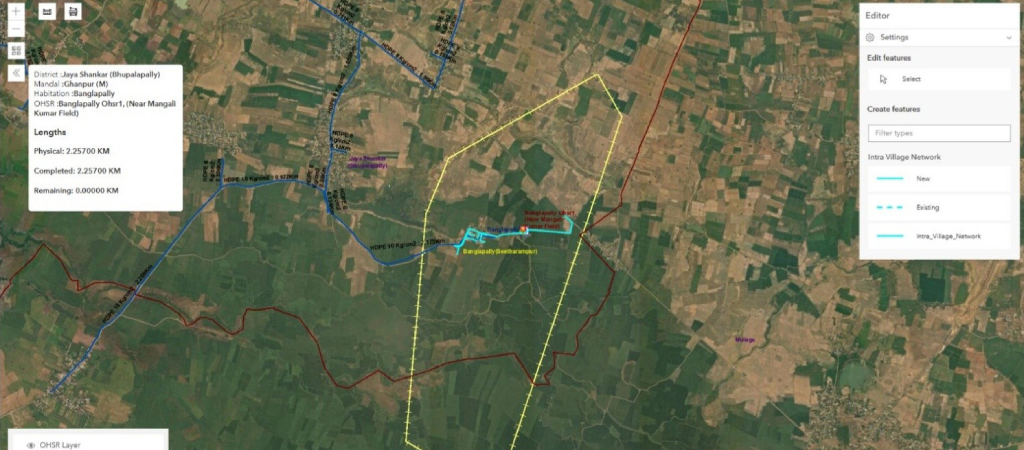 Fig: 9.3 : Intra-Village Water Supply Network
Administrative Coverage
- 32 Districts
- 99 Constituencies
- 31 Segments
- 572 Mandals
- 23,671 Rural Habitations
- 943 Urban Habitations
Source and Intake Infrastructure
- 32 Surface Water Sources
- 78 Intake Structures
Treatment & Storage Infrastructure
- 123 Water Treatment Plants (WTPs)
- 775 Sumps
- 190 Ground Level Balancing Reservoirs (GLBRs)
- 210 Break Pressure Tanks (BPTs)
- 691 Overhead Balancing Reservoirs (OHBRs)
- 36,473 Village OHSRs
Network Infrastructure and Coverage
- 1.35 lakh km of pipeline network
- 292 Bulk Water Supply connections
- Coverage of approximately 2.4 crore population
This extensive geospatial repository provides a unified and reliable data foundation, enabling coordinated infrastructure management and informed decision-making at all administrative levels.
Integration with National-Level Digital Platforms
The WebGIS platform is integrated with the PM Gati Shakti National Master Plan (NMP) Portal, enabling structured geospatial data exchange and standardized integration of pipeline network layers into the national infrastructure framework. This integration facilitates alignment between State-level infrastructure systems and national planning initiatives, ensuring greater coherence in infrastructure development. Seamless interoperability with the Gati Shakti platform also supports coordinated, multi-sectoral planning across key domains such as roads, power, irrigation, and telecommunications. By situating water infrastructure within a broader national geospatial ecosystem, the platform strengthens cross-departmental collaboration and integrated decision-making.
Transparency & Accountability
The deployment of GIS-enabled mapping and analytical dashboards has strengthened transparency in system monitoring and service delivery. By providing access to reliable, location- based data, the platform enables more consistent and evidence-based oversight across administrative levels. With role-based access to verified geospatial information, decision-makers can monitor infrastructure performance and service status in near real time. This improves traceability of assets and operations, supports timely identification of service gaps, and enables more accountable, outcome- oriented governance. By shifting from fragmented reporting to a unified spatial data framework, the system enhances both visibility and institutional accountability in rural water supply management.
Conclusion
The Mission Bhagiratha WebGIS platform represents a comprehensive, technology-enabled framework for next-generation water governance. By integrating end-to-end asset geotagging, habitation-level service monitoring, real-time analytical dashboards, high-resolution satellite imagery, water quality surveillance, and interoperable data linkages, the platform has significantly strengthened the planning, monitoring, and management of rural water supply infrastructure. More importantly, it demonstrates a shift from static infrastructure management to a dynamic, data-driven governance model. The ability to visualize, Analyse, and monitor the entire water supply network within a unified geospatial environment has improved operational efficiency, enhanced service reliability, and enabled more responsive decision-making. As a scalable and interoperable system, the platform offers a replicable model for other states and sectors seeking to adopt geospatial technologies for large-scale public service delivery.
- Edited by:NISSY GEORGE
Author / Contributor

Guntuku Prasad Dy. Director General & SIO gprasad[at]nic[dot]in

T Bala Sundaram Sr. Technical Director & HoD balasundaram[at]nic[dot]in

Kartik Krishna Vijayasharadhi Scientist - D kartik.m[at]gov[dot]in
- Tag:
- Internet
- Technology
- eGov
- Tech
State Informatics Officer
NIC Telangana State Centre
A-Block, BRKR Bhawan, Tank Bund Road
Hyderabad, Telangana – 500004