
The Odisha Disaster Resource Network (ODRN) is a centralized GIS-based digital platform odrn.nic.in for resource management, designed to enhance disaster preparedness, response, and recovery in Odisha by tracking and managing critical resources, including human, infrastructure, and equipment resources needed during disasters such as cyclones, floods, droughts, and other emergencies.
The Odisha State Disaster Management Authority (OSDMA), established in 1999, is the state’s apex body for disaster management and resilience building. The Odisha Disaster Resource Network (ODRN) complements its efforts by serving as a centralized, GIS-based database of manpower, infrastructure, and equipment across all administrative levels. By providing real-time, location-specific information, ODRN supports disaster management planning, enables swift mobilization of resources, and strengthens coordination among agencies. This technology-driven platform enhances preparedness, reduces risks, and builds resilience across Odisha.
Objectives
- Resource Inventory Management – Maintains an updated database of emergency resources, including equipment, human, and infrastructure
- Real-time Accessibility – Provides quick access to information on resource availability for government agencies and disaster management teams
- Coordination & Rapid Response – Facilitates better coordination among various departments and stakeholders for efficient disaster response
- Transparency & Accountability – Ensures proper tracking and utilization of resources to prevent mismanagement and delays
- Integration with Disaster Management Plans – Aligns with emergency response frameworks for a well-coordinated disaster management strategy
Features
- GIS-Enabled Mapping – Visualizes shelters, equipment, manpower, and other assets across State, District, Block, and Gram Panchayat levels, ensuring easy deployment during emergencies.
- Resource Planning & Mobilization – Helps administrations allocate rescue teams, shelters, and equipment effectively during disasters.
- Planning Support – Assists in preparing Disaster Management Plans (DMPs) at all levels using spatial data and updated inventories.
- Secure Access & Web Availability – Provides role-based login for authorized officials with secure, multi-platform access to support quick decision-making.
Functionalities
- Resource Inventory Management – Maintains a comprehensive, regularly updated database of manpower, infrastructure, and equipment at state, district, and block levels
- GIS-Based Visualization – Provides map-based display of resources, shelter capacities, and routes for quick identification, mobilization, and spatial analysis of disaster-prone areas
- Planning & Decision Support – Assists in preparing and updating Disaster Management Plans, identifies resource gaps, and informs procurement and capacity-building
- Emergency Resource Mobilization – Enables real-time identification of nearest resources, ensuring efficient logistics, allocation, and deployment during disasters
- Inter-Agency Coordination – Strengthens collaboration among OSDMA, district authorities, line departments, ODRAF, SDRF, and NDRF
- Reporting & Documentation – Generates customized reports on resources, infrastructure, readiness, and deployment, supporting audits and post-disaster reviews
- User Access & Security – Provides role-based login for officials at different levels, ensuring secure, confidential, and controlled access to information
- Information Support – Keeps officials updated on available resources through a centralized system
- User Management – Allows controlled addition and management of authorized users
- MIS Report Generation – Creates management information system reports for planning, monitoring, and evaluation
Technologies Used
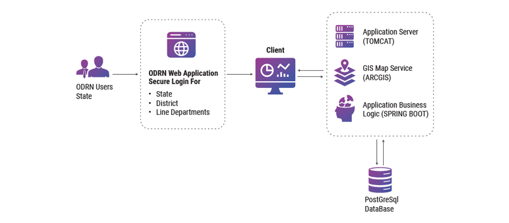 8.1 Software Architecture
The ODRN application is developed using Spring Boot on the Model-View-Controller (MVC) framework, ensuring a clean, scalable, and maintainable codebase. This architecture enables seamless interaction between front-end and back-end components, efficient data flow, and modular development. Designed with a modular structure, secure data management, responsive user interface, advanced visualization tools, and integrated geospatial intelligence, the system provides both reliability and flexibility for disaster management operations.
Backend Layer
- Framework: Spring Boot provides a robust, production-ready environment for web applications
- Database: PostgreSQL ensures secure data storage, fast query execution, and reliable performance
- Data Handling: Supports secure management of user data with proper transaction handling and integrity checks
Presentation Layer
- Template Engine: Thymeleaf is used for dynamic content rendering
- User Interface: Built with Bootstrap for a responsive, mobile-friendly, and accessible design
- Data Visualization: Chart.js powers interactive dashboards, enabling users to interpret and analyze complex data easily
Integration & GIS Capabilities
- NICMAP Service API: Integrates geospatial functionalities through Bharat Map GIS, allowing spatial mapping, visualization, and location-based insights
- Decision Support: Enhances disaster planning and response by combining resource data with geospatial intelligence
Benefits
- Improved Resource Visibility & Tracking – Maps manpower, infrastructure, and equipment across locations, helping authorities quickly identify available resources, avoid duplication, and ensure better utilization
- Faster & More Effective Response – Pre-mapped resources enable quicker mobilization, reducing delays and saving lives
- Better Preparedness – Highlights resource gaps in advance, supporting disaster management plans at state, district, block, and Gram Panchayat levels
- Coordinated Planning – Centralized yet location-specific data improves coordination across all administrative levels
- Efficient Recovery – Resource availability data supports faster and more effective recovery planning
- Transparent Decision-Making – Regularly updated, mapped data reduces ambiguity, enhances accountability, and builds public trust
- Optimized Resource Allocation – Matches needs with available resources, allowing pre-positioning in high-risk areas and preventing wastage
- Scalability & Dynamic Updating – GIS-based system allows continuous updates as resources change or are redistributed
- Risk Reduction & Resilience – Identifies recurring gaps and vulnerabilities, helping Odisha strengthen resilience over time
- Integration with Other Systems – Supports smoother functioning of the overall disaster management ecosystem
Odisha Disaster Resource Network (ODRN) application is a tool for OSDMA and the state of Odisha, as it centralizes information on infrastructure, equipment, and manpower with a GIS-based platform. It enables quick identification and mobilization of critical resources during disasters, thereby reducing response time and ensuring timely rescue and relief operations. By mapping resources at Gram Panchayat, Block, District, and State levels, it strengthens preparedness and improves planning for disaster management and mitigation. It fosters better coordination among different stakeholders, ensuring smooth disaster management efforts. Transparency and accountability in resource use are enhanced, boosting efficiency. Ultimately, ODRN helps in minimizing the impact of disasters and contributes to achieving the ZERO CASUALTY MISSION.
I would like to congratulate the NIC Odisha team for providing technical support and the officials of OSDMA for making this a successful project.

Dr. Kamal Lochan Mishra, IAS
Executive Director, OSDMAWay Forward
The future of ODRN lies in strengthening real-time tracking of critical resources through GPS/RFID and live dashboards, and integrating with Odisha’s Early Warning Systems for pre-disaster mobilization. A mobile app with offline access will enhance usability in remote areas, while synchronization with Health, Police, Fire Services, and other departments will ensure coordinated action. By applying AI and predictive analytics, ODRN can identify resource gaps, generate readiness scores, and guide better planning. These advancements will make Odisha’s disaster response more dynamic, coordinated, and resilient, advancing the state’s “Zero Casualty Mission.”
- Edited by:Nissy George
Author / Contributor

Dr. Ashok Kumar Hota Dy. Director General & SIO ak.hota[at]nic.in

Mamata Khamari Dy. Director General m.khamari[at]nic.in

Jayanta Kumar Mishra Sr. Technical Director jkmishra[at]nic.in

Rabindra Kumar Moharana Technical Director rabindra.moharana[at]nic.in
- Tag:
- Internet
- Technology
- eGov
- Tech
Rabindra Kumar Moharana
Technical Director
NIC, Odisha State Centre
Sachavalaya Marg, Unit-IV,
Bhubaneswar, Odisha - 751001